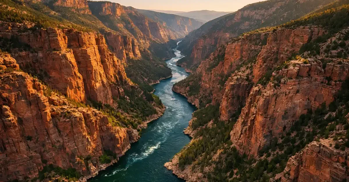
For over 150 years, geologists have puzzled over a geographical riddle in the American West that appeared to defy the laws of physics. The Green River, the largest tributary of the Colorado River, follows a baffling path through the Uinta Mountains in northeastern Utah. Instead of flowing around the high peaks as gravity would typically dictate, the river cuts directly through the mountain range, carving the deep Canyon of Lodore. This geological anomaly has sparked debate since the days of 19th-century explorer John Wesley Powell. Now, a new study suggests that a massive, invisible instability deep beneath the Earth’s surface—known as a “lithospheric drip”—is the culprit behind this impossible route.
The central mystery lies in the timing and topography of the region. Rivers naturally seek the path of least resistance, flowing downhill and skirting around obstacles like mountain ranges. However, the Green River runs perpendicular to the Uinta Mountains, slicing through rock that is approximately 50 million years old. The river itself is much younger, having established its course less than eight million years ago. This discrepancy led to the confusing conclusion that the river must have somehow flowed “uphill” or maintained its path while the mountains rose around it. A team of international researchers has now provided a compelling explanation that resolves this paradox: the river did not climb the mountains; the mountains temporarily lowered themselves to let the river pass.
The Mechanism of a Sinking Mountain
The study, published in the Journal of Geophysical Research: Earth Surface, proposes that the Uinta Mountains were pulled downward by a dense blob of mantle rock. This phenomenon, called lithospheric drip, occurs when a heavy, mineral-rich layer at the base of the Earth’s crust becomes unstable. Like a drop of cold molasses clinging to a spoon, this dense root of the mountain range grew too heavy to support itself and began to slowly drip into the hotter, more fluid mantle below.
According to Dr. Adam Smith, a geologist at the University of Glasgow and lead author of the study, this deep-earth process warped the surface topography. As the heavy drip sank, it tugged the overlying crust downward, creating a depression or basin where the mountains stood. This temporary lowering of the landscape provided a crucial opening. Gravity could then guide the Green River across the subsided mountain range, allowing it to cut its channel.
Once the dripping blob eventually broke off and detached into the deeper mantle—an event estimated to have occurred between two and five million years ago—the weight dragging on the crust was released. The mountain range, now unburdened, rebounded and rose back up. By this time, however, the Green River had already etched its deep path. As the mountains lifted around it, the river continued to cut downward, deepening the Canyon of Lodore and cementing its unlikely route through the high peaks.
Seismic Evidence of a “Dripping” Crust
To test this theory, the research team utilized seismic imaging, a technique comparable to a medical CT scan for the planet. By analyzing how earthquake vibrations travel through the Earth, they reconstructed a picture of the subsurface structures beneath the Uinta Mountains. The images revealed a distinct, cold, round anomaly located approximately 125 miles (200 kilometers) beneath the surface. The researchers identified this isolated mass as the detached remnants of the lithospheric drip.
Further evidence came from measuring the thickness of the Earth’s crust in the region. The study found that the crust beneath the Uinta Mountains is significantly thinner than what would be expected for a mountain range of its height. This thinning is consistent with the lower layers having dripped away into the mantle. Additionally, the team identified a telltale “bullseye” pattern of uplift on the surface, which matches the theoretical rebound that would occur after a drip detaches. The calculated elevation change from this rebound aligns with the roughly 1,300-foot (400-meter) vertical shift observed in the river network.
Resolving a Century-Old Debate
This discovery offers a resolution to competing theories that have divided the geological community for generations. Previous explanations included “antecedence,” the idea that the river existed before the mountains rose, and “superposition,” which suggested the mountains were once buried in sediment that the river flowed over before cutting down into the buried peaks. Other theories proposed that erosion from the south might have “captured” the river.
Dr. Smith notes that the new evidence strongly contradicts these older ideas. The data shows that the river did not predate the mountains, nor was there enough sediment to bury the range. Instead, the dynamic interaction between the deep mantle and the surface crust drove the landscape changes.
The merging of the Green River with the Colorado River was a pivotal event in North American geology. It shifted the continental divide, redefining which waters flowed to the Pacific Ocean and which to the Atlantic. This change also created new boundaries for wildlife habitats, influencing the evolution of species in the region. By solving the mystery of the Green River, scientists have not only explained a local oddity but also demonstrated how deep-earth dynamics can dramatically shape the surface world.
