Spain’s run of severe weather has pushed rainfall to its highest level for January and February in 47 years, according to the national weather agency AEMET, after 11 major storms swept across the country from late December to mid-February. The wet start to 2026 has turned Spain storms into a major national story, with heavy rain, strong winds and flooding hitting several regions and adding to concerns about how extreme weather is changing across the Iberian Peninsula.
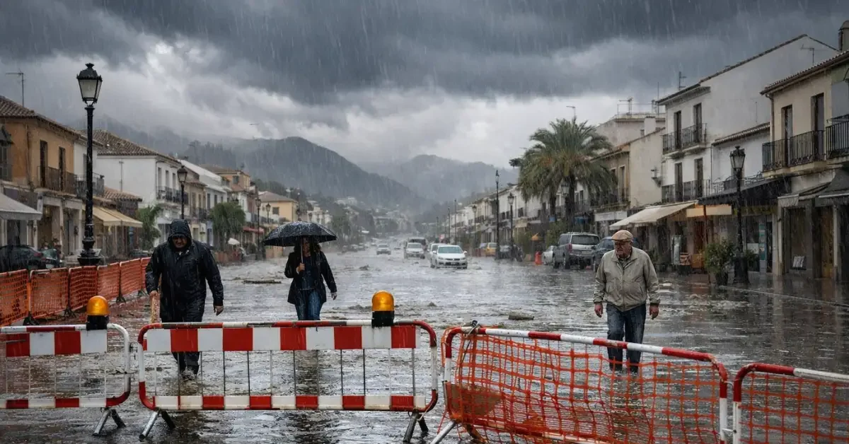
Storm Leonardo was one of the most damaging episodes in that stretch. In Grazalema, one of the hardest-hit towns in southern Spain, more than a full year’s expected rainfall fell in just a few days during the storm, authorities evacuated the entire town because of flooding and landslide risks, and two people died as a result of the storm.
The unsettled pattern has continued into March. A new isolated high-altitude depression, known in Spain as a DANA, moved in at the start of the week and is expected to bring three days of heavy rain, thunderstorms and snow to many parts of the country, with eastern and southern areas facing some of the most disruptive conditions.
Wettest start in decades
AEMET spokesman Ruben del Campo said January and February 2026 were the rainiest first two months of the year in the last 47 years, underlining how unusual the weather has been. He also said Spain has now gone through its eighth straight warm or very warm winter, with temperatures above average in a streak that AEMET described as unprecedented in its records.
The wider Iberian Peninsula has also been drenched. Portugal recorded its wettest February in 47 years, according to the Portuguese meteorological agency IPMA, showing that the same broad weather pattern has affected both countries.
A separate report in Chosun Ilbo’s English edition said the Iberian Peninsula was hit by two consecutive storms earlier this year and linked the region’s unusual weather, along with extreme cold in northern Europe, to shifting jet stream patterns and climate change. That report said experts believe a southward-shifted jet stream and blocking high pressure helped trap rain systems over parts of Europe, allowing wet conditions to last longer than normal.
Fresh March disruption
The latest DANA is bringing another round of unstable weather just as meteorological spring begins. On Monday, precipitation was forecast to spread from the northwest toward Castilla y Leon, Madrid, Castilla-La Mancha, Extremadura, Andalusia and parts of the southeast interior, while colder air aloft was expected to bring snow back to interior mountain areas.
Tuesday was forecast to be the most disruptive day in the southeast. Heavy, thundery downpours were expected to intensify across eastern Andalusia, the Strait area, Ceuta, Melilla, Murcia, eastern Almeria and the Valencian Community, while mountainous parts of the southeast faced continued snow warnings. In places such as Guadix-Baza in Granada province, snowfall was expected to exceed 5 centimeters, with snow levels falling below 1,000 meters in some areas.
By Wednesday, rain was expected to continue mainly in the Valencian Community, eastern and southeastern zones, Melilla and eastern Andalusian provinces before gradually easing as the system weakened. Temperatures were then expected to begin a slight recovery, although the broader pattern for March remained unstable.
Travel and public warnings
The Traveler reported that AEMET had placed multiple Spanish regions under yellow and orange alerts as the March DANA disrupted early spring weather across the Iberian Peninsula. The report said the storm could bring heavy rain, thunderstorms, strong winds and hazardous seas to popular coastal destinations, raising the risk of road closures, ferry changes and travel delays.
Along the southern coast, alerts covered parts of Andalusia, including stretches of the Costa del Sol and Costa de la Luz, while inland provinces such as Granada and Jaen faced snowfall warnings that could affect mountain roads and pass connections. Further east, the Costa Blanca and wider Valencia and Murcia regions were also under storm alerts, with authorities warning about short, torrential downpours that could flood low-lying streets and underpasses.
Climate pressure builds
Del Campo said the severity of Leonardo showed the footprint of climate change because warmer oceans increase evaporation and a warmer atmosphere can hold more water vapor, which leads to heavier rainfall. The Chosun report also noted that for every 1 degree Celsius rise in atmospheric temperature, air can retain about 7 percent more moisture, a change that can make storms wetter as the planet warms.
AEMET now sees a 50 percent to 70 percent probability that the coming spring in Spain will also be warmer than usual. After the wettest start to the year in nearly half a century, Spain is heading into the next season with the ground already saturated in many places and another reminder that extreme swings between warmth and intense rain are becoming harder to ignore.
