Recent scientific research reveals that thawing Arctic permafrost is unlocking ancient carbon reserves at an alarming and unprecedented rate. As global temperatures continue to climb, the frozen ground covering much of the northern hemisphere is undergoing severe physical and hydrological transformations. These rapid changes are breaking down historic natural barriers, releasing massive amounts of greenhouse gases directly into the atmosphere and surrounding oceans.
Two breakthrough studies provide a detailed look at how thawing Arctic permafrost is reshaping the global climate landscape. Scientists have discovered that melting frozen soil becomes vastly more porous, allowing trapped methane and carbon dioxide to escape much faster than previously anticipated. Simultaneously, expanding river networks across the tundra are carrying increasing levels of dissolved organic carbon into coastal waters. Together, these processes create a dangerous, self-reinforcing cycle where warming drives further carbon release, which in turn accelerates global temperature increases.
Dramatically Increased Soil Permeability
Experimental research led by the University of Leeds demonstrates a staggering shift in the physical structure of frozen ground. As permafrost thaws, it becomes between 25 and 100 times more permeable. This extreme increase in porosity essentially transforms a solid barrier into a conduit, creating new pathways for trapped climate-forcing gases to migrate upward and escape into the air.
Researchers tested model permafrost in a petrophysics laboratory, tracking how changing temperatures influence gas flow and volume. By thawing samples gradually from -18 degrees Celsius to 5 degrees Celsius, they pinpointed the exact conditions that trigger the most significant structural breakdown. The most dramatic changes in permeability occur in the narrow temperature window between -5 degrees Celsius and 1 degree Celsius.
The sheer scale of the trapped gases highlights the severity of this shift. Globally, permafrost is estimated to contain approximately 1,700 billion metric tons of carbon. This represents roughly three times the total amount of carbon currently residing in the Earth’s atmosphere. With the Arctic region warming four times faster than the rest of the planet, these frozen carbon sinks face immediate threats. Experts predict a 42% loss of frozen soil coverage in the Arctic Circumpolar Permafrost Region by the year 2050. Furthermore, the thawing process may release radon, a cancer-causing radioactive gas that poses a severe health risk to northern communities.
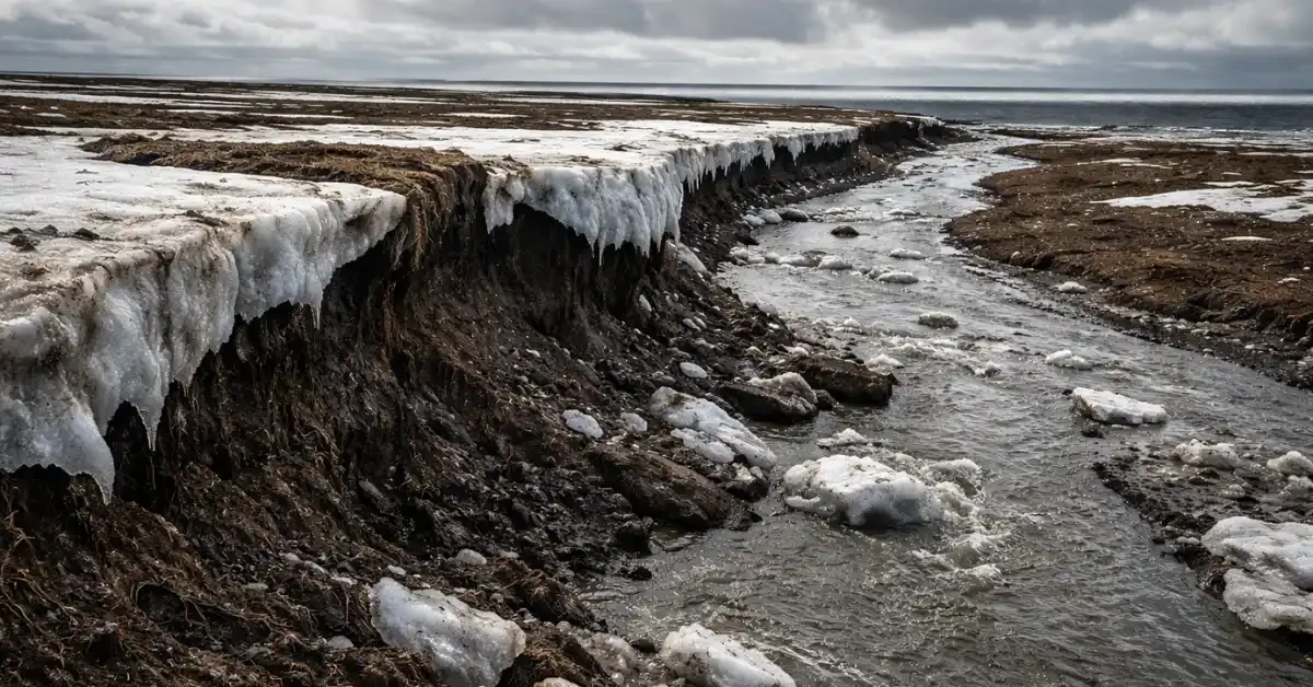
Expanding River Networks and Ancient Carbon
While increased soil permeability releases gases directly into the air, thawing permafrost is also transforming regional water systems. A comprehensive study led by the University of Massachusetts Amherst offers unprecedented insight into how warming reshapes Arctic rivers. Focusing on a region of Alaska’s North Slope roughly the size of Wisconsin, researchers utilized a highly detailed model to track water and carbon movement.
The frozen ground features an upper section known as the active layer, which naturally freezes and thaws each year. As the climate warms, this active layer is deepening significantly. A deeper active layer allows more groundwater to flow into the hundreds of rivers and streams that drain into the Beaufort Sea. Consequently, the rivers carry dissolved organic carbon—material that has been frozen and decaying for tens of thousands of years—away from the permafrost and into the ocean.
Arctic rivers possess an outsized influence on global aquatic systems. They deliver approximately 11% of the world’s river water into the Arctic Ocean, an ocean that contains just 1% of the global ocean volume. As the ground thaws, the Arctic Ocean absorbs a disproportionate amount of ancient carbon. Every year, over 275 million tons of this dissolved organic carbon convert into carbon dioxide, significantly adding to global warming.
Regional Variations and Future Climate Risks
To capture these shifts, scientists modeled 44 years of daily river flow and coastal export data from 1980 to 2023. Unlike previous models that relied on 25-kilometer grid cells, this massive simulation operated at a one-kilometer resolution. Processing this enormous dataset required ten continuous days on a supercomputer at the Massachusetts Green High Performance Computing Center.
The detailed modeling revealed distinct regional variations in carbon release. Northwest Alaska exhibits the highest increases in carbon export. The flatter terrain in this region holds deep, rich deposits of ancient carbon accumulating over millennia. Moving eastward, the landscape becomes more mountainous with rockier, sandier soil, resulting in far less mobilized carbon as the ground thaws.
Looking ahead, the projections paint a concerning picture for the region’s future. Over the next 80 years, the Arctic could experience up to 25% more river runoff and a 30% increase in subsurface water flow, alongside increasing dryness in southern areas. Furthermore, the thaw season is visibly extending, now stretching into late summer and through October. These profound environmental shifts are likely to disrupt salinity levels, nutrient cycles, and complex food webs within the Beaufort Sea and beyond, emphasizing the urgent need to understand the connection between land changes and coastal ecosystems.
